Introduction
This page is titled Crown Farm since that is its name at the time of writing. As will be seen below, there have been several other names, in addition to which in previous years farms were more often identified by the name of their occupiers.
Pevsner’s guide describes the farmhouse as
T-shaped C16 timber-framed and brick house. The ground floor is brick, but the first floor is jettied – a real mixture, repeated in the north and south gable-ends – in the manner of contemporary Norwich houses. The façade has mullioned and transomed windows below, casements above. Gable stacks, that to the south with four octagonal flues. To the rear are some arched braces on studs supporting the jetty bressumer.1
- Introduction
- 1811-1819
- 1814 Enclosures Map
- 1815 Survey of Deopham
- 1838 Called High Elm Farm
- 1843 Tithe Apportionment map
- 1877 Escheat
- 1884 Farm is called Old Farm
- 1892 Lease
- 1898 Farm became Crown Farm
- 1907 Ordnance Survey Map
- 1941 Farm Survey
- 1945 Bomber Crash
- 2025
- Footnotes
1811-1819
During the period 1811 to 1819, the affairs of Crown Farm were managed by the Rev. Bence Bence on behalf of Bevil Amyas, the farm’s owner, who had been declared unfit to manage his own affairs. At the end of this period, the Rev. Bence Bence forwarded a detailed set of accounts listing his expenses in maintaining the farm. The originals of these accounts are reproduced here. The following table summarises the sums expended in looking after the farm during the years of the Rev. Bence Bence’s trusteeship. All values are in £-s-d.
During this period, the occupier was recorded in these accounts as being Oddin Taylor.
| Year: | 1811 | 1812 | 1813 | 1814 | 1815 | 1816 | 1817 | 1818 | 1819 | |
|---|---|---|---|---|---|---|---|---|---|---|
| Tradesman | Trade | |||||||||
| Harwood | Carpenter | £1-12-3 | £4-3-7 | £2-7-3 | £2-9-8 | |||||
| Haythorpe | Carpenter | £5-4-1½ | £4-12-5 | £9-10-8 | £4-4-7 | £10-12-4 | ||||
| Lovett | Mason | 15-7½ | £2-1-4 | £2-11-4 | £3-18-6½ | £6-13-7 | £4-18-9 | £3-2-0 | £2-4-9½ | £6-3-1 |
| Fenix | Thatcher | £3-19-10 | 4-10 | £1-9-4 | £2-14-4 | £1-0-2 | £1-8-2 | £3-13-8 | ||
| Badcock | Blacksmith | 2-10 | 3-6 | 4-7 | 9-8 | 3-5 | ||||
| Ward | Blacksmith | 2-6 | 16-9½ | 12-4 | 11-6 | |||||
| Watson | Tiles | £3-2-10 | £3-3-6 | £4-16-2 | ||||||
| Watson | Bricks | £3-0-3 | £1-1-3 | £4-8-9 | £2-10-3 | £4-0-8 | ||||
| Easton | Bricks | 10-0 | ||||||||
| Fisk | Deals | £1-10-3 | ||||||||
| Clarke | Bricks | £2-0-0 | £8-6-6 | |||||||
| Clarke | Splints | 14-0 | 16-8 | |||||||
| Barnes | Lime | 3-4 | 6-8 | 6-8 | 17-4 | 13-4 | £1-13-4 | 3-4 | £1-16-8 | |
| – | Bunches of Reed | 7-6 | ||||||||
| – | Bunches of Lath | 6-0 |
1814 Enclosures Map
This map shows clearly that there was a moat around three sides of the farmhouse.
The farm is shown as being the property of Bevil Amyas. The analysis which accompanies this map reads:
… and we assign set out and allot unto Bevil Amyas the six pieces of land Land next hereinafter described namely First one piece land marked on the Map hereto annexed No 10 containing one hundred and thirty six acres and twenty two perches with a Messuage and other buildings standing thereon ….

All rights reserved by Norfolk Record Office who hold the original; their ref is NRO C/Sca 2/86
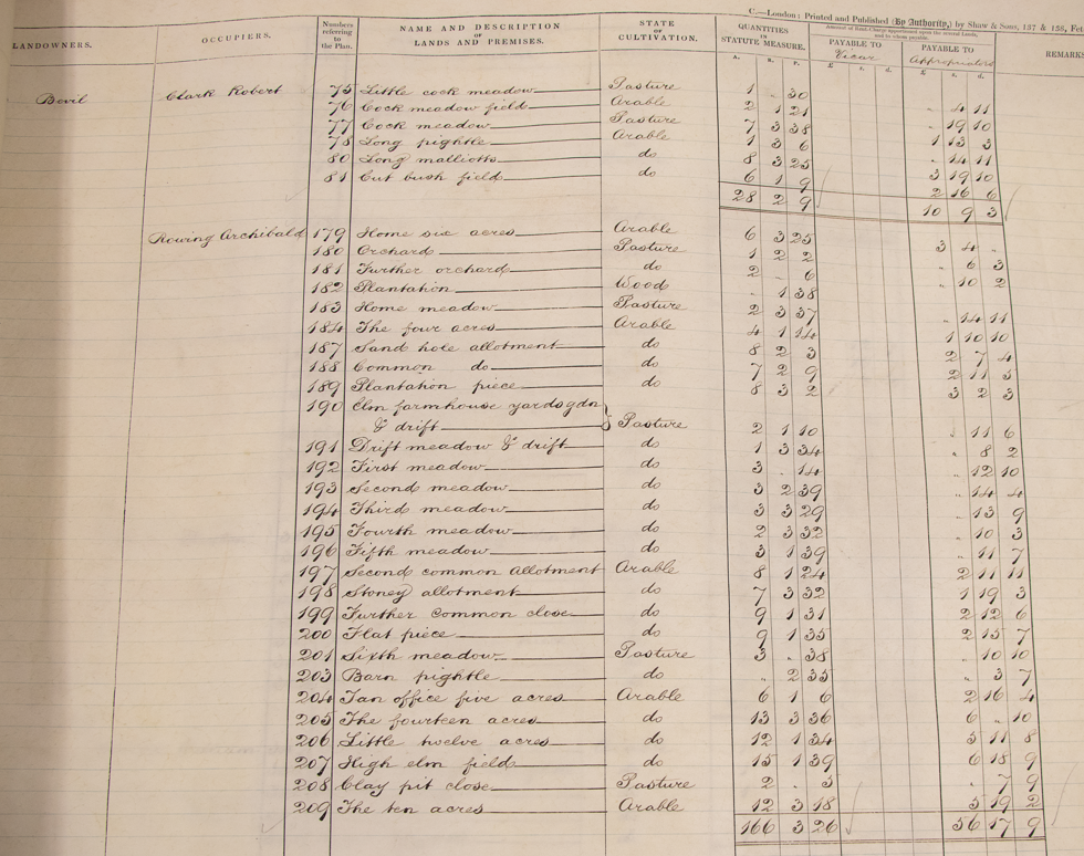
1815 Survey of Deopham
This survey of the village recorded in 1815 shows that the farm occupied by Garett Oddin Taylor comprised 133 acres of arable and 35 acres of pasture. The details are listed here.
1838 Called High Elm Farm

This 1838 map shows that at this time the farm was known as High Elm Farm (one of two – one each side of what is now Vicarage Road!)
1843 Tithe Apportionment map
This map has been rotated to give the same orientation as the other maps on this page (north to the top).

All rights reserved by Norfolk Record Office who hold the original; their ref is NRO DN/TA 743
The following analysis accompanies the above map and shows that the farm was owned by Bevil Amyas and farmed by Archibald Rowing. It comprised 166 acres, and necessitated a tithe payment of £56 per annum to the Dean and Chapter of Canterbury.
The name of the farm at this time cannot be determined, even though each field has a name.
All rights reserved by Norfolk Record Office who hold the original; their ref is NRO DN/TA 743
1877 Escheat
Following the death of Bevil Amyas in 1876, since he had been unable to make a will, there was an escheat. Since no relatives came forward to successfully claim title to the farm, ownership passed to the Crown. It was however not until around 1898 that the name of the farm became “Crown Farm” in order to avoid problems with there being two Hall Farms, both occupied by Allens. This is explained in Michael Allen’s recollections.
1884 Farm is called Old Farm
At the time of this 1884 Ordnance Survey map, the farm was shown as “Old Farm”. The blue to the north of the farmhouse would indicate that there was still a part of the moat intact at this date.
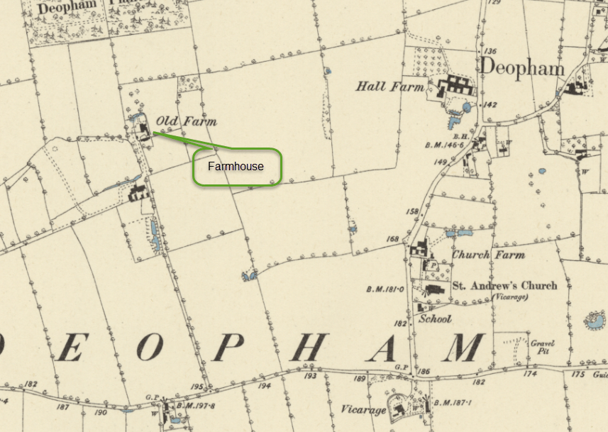
Reproduced with the permission of the National Library of Scotland
1892 Lease
The following maps are from an agreement dated 1892 for William Allen to take on the lease of Hall Farm (now known as Crown Farm). The document is behind glass so difficult to photograph clearly; furthermore, it was folded in half before framing so not all is visible.

Most of the land in scope for this transaction was located around the farmhouse; the plan above includes a satellite area in blue (shown in close up below) described on the plan as “Distance about 1 mile” from the main area of farmland. It is easier to see the context of this area on the extract from the following OS map published in 1814.


Reproduced with the permission of the National Library of Scotland
The pieces of land in this satellite area were:
| Piece number | Name |
|---|---|
| 360 | Long Malliots & Cut Brushfield |
| 384 | Cock Meadow |
| 385 | Long Pightle |
| 386 | Little Cock Meadow & Cock Meadow Field |
The following image shows the first part of the lease agreement from which the above maps were taken between the “The Queen’s Most Excellent Majesty” and William Allen of Deopham, Farmer, for what is now known as Crown Farm:

Thanks to Michael Allen for sight of this document in October 2022.
1898 Farm became Crown Farm
See the comments above under the heading “Escheat”, and the links in that paragraph.
1907 Ordnance Survey Map

This extract from the 1907 O.S. map shows that the farm’s name had become “Crown Farm” by this time.
1941 Farm Survey
Details of the 1941 Farm Survey are available here. At that time, the farm was managed as “Hingham Nurseries” by Mr. Frank Law, who subsequently took on Mill Farm.
1945 Bomber Crash

On February 6th 1945 a B24 Liberator bomber assigned to the 734th Bomb Squadron 453rd Bomb Group based at Old Buckenham crashed some fifty yards from the house at Crown Farm.
The full story can be read here.
2025
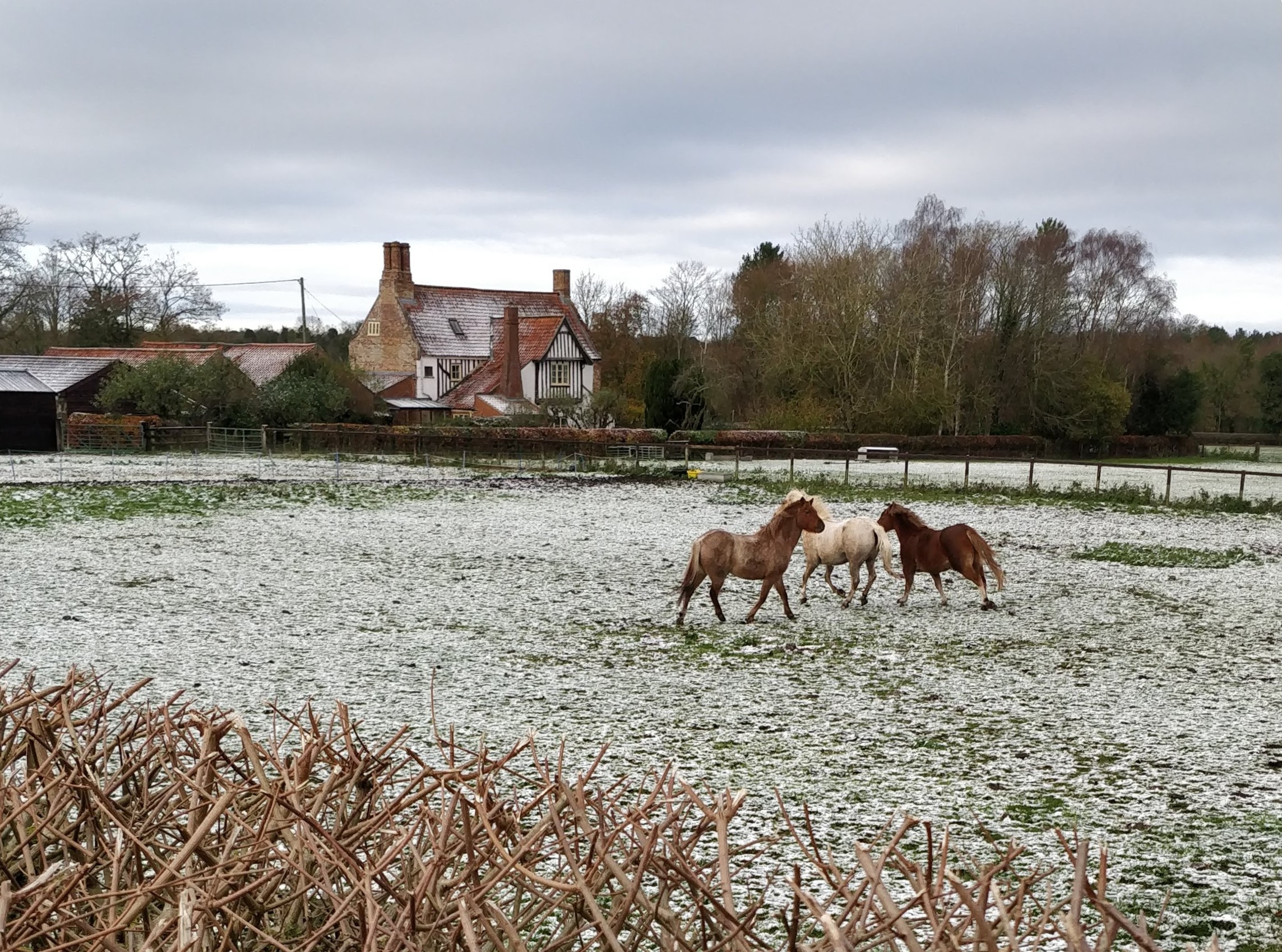
Photo: G. Sankey, 11/2025
Footnotes
- Nikolaus Pevsner & Bill Wilson: The Buildings of England. Norfolk 2: North West and South, pg 282 ↩︎
| Date | Change |
|---|---|
| 16/12/25 | 11/2025 photo |
| 31/8/25 | 1892 lease |
| 28/12/23 | Published |
