Other spellings: Haugh Field, Hawfield, Hawefield
Contents
Introduction
There are many references to the Haughfield in the records of the Manorial Courts, with it being used to identify plots of land within the Haughfield, or adjacent to it.
Location
1815 Survey
The 1815 survey has several references to Haughfield which are fortunately identified on an accompanying map.
| Map reference | Description | Acres | Roods | Perches |
|---|---|---|---|---|
| 306 | Allotment in Haugh Field | 1 | 1 | 34 |
| 266 | Haugh Field | 2 | 3 | 1 |
| 272 | Haugh Field | 2 | 0 | 14 |
| 273 | Haugh Field | 4 | 1 | 24 |
| 274 | Haugh Field | 3 | 3 | 18 |
| 275 | Haugh Field | 2 | 0 | 12 |
| 276 | Haugh Field | 2 | 2 | 23 |
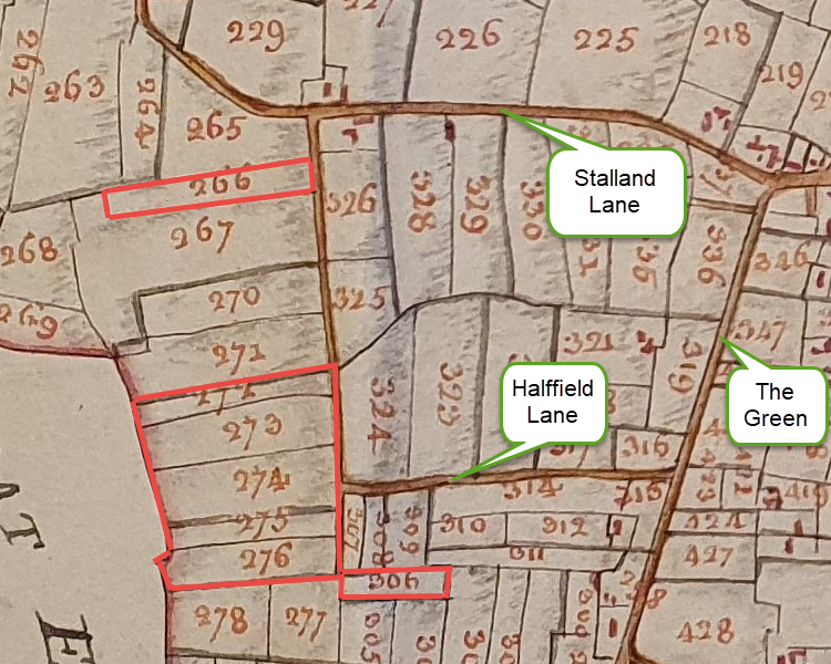
Reproduced courtesy of the Chapter of Canterbury; their ref 183720-17
1843 Tithe Map
| Map Reference | Description | Acres | Roods | Perches |
|---|---|---|---|---|
| 339 | Haughs field | 4 | 3 | 6 |
| 341 | Haugh field | 3 | 1 | 28 |
| 342 | Haugh Field Lane piece | 3 | 3 | 36 |
| 343 | Haugh field pightle | 2 | 0 | 10 |
| 344 | Further haugh field pightle | 2 | 2 | 6 |
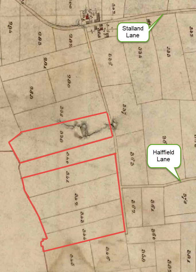
All rights reserved by Norfolk Record Office who hold the original; their ref is NRO DN/TA 743
Origin of the name
The parallel existence of the names Hawfield and Haughfield is as yet unexplained, although the way in which a property definition is handed down from generation to generation without review could mean that a single error has been perpetuated in that tradition.
Haughfield
In Scotland and northern England, Haugh referred to a low-lying meadow by the side of a river, which is not applicable to the land defined above. The word “Haugh” is derived from the Old English word healh which meant primarily a “corner,” “nook,” “recess,” or a “hidden, remote place”. This would be appropriate to the area known as Haughfield which is on the Gt. Ellingham boundary, right on the edge of Deopham.
Hawfield
Haw has its origins in the meanings hedge, hawthorn, enclosure. The meaning of Deopham’s Hawfield could therefore have been “a field marked by hawthorn” or “an enclosed field”.
Halffield
This may be an evolution of the healh discussed above, but equally probable is that it evolved from Haughfield with influence from the pub on the corner of Haughfield Lane being called the Half Moon.
Navigation
| Date | Change |
|---|---|
| 31/5/26 | Published |

