Contents
1814
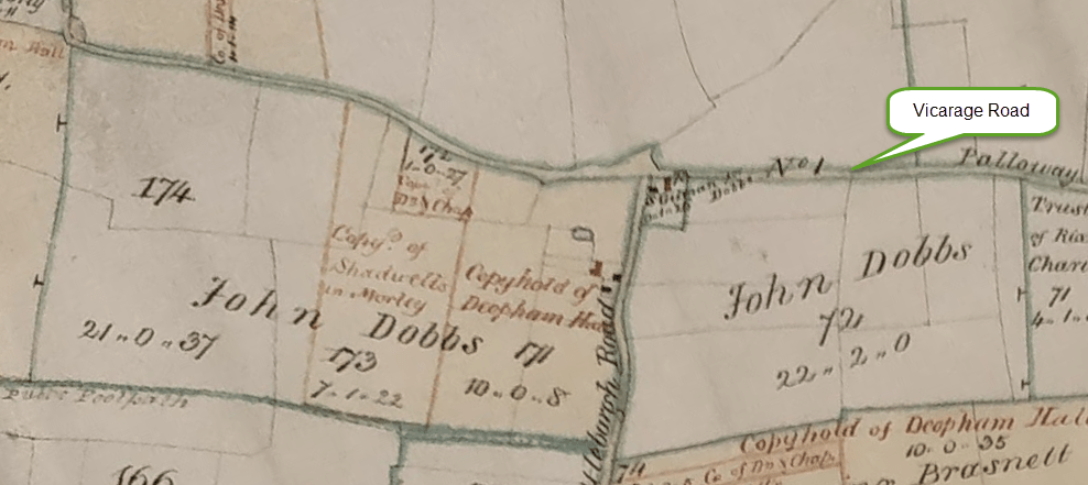
In 1814 the map shows that John Dobbs owned the land both east and west of the Attleborough Road (now called Pye Lane).
All rights reserved by Norfolk Record Office who hold the original; their ref is NRO DN/TA 743
The 1812 Deopham Inclosure report lists John Dobbs as owning 53 acres.
The 1815 Survey of Deopham shows that John Dobbs owned and farmed
59 acres 32 perches of arable land plus
3 acres 22 perches of pasture making a total of
62 acres 1 rood and 14 perches.
This corresponds to the land shown in the extract above from the 1814 plan:
| Piece No | Acres | Roods | Perches |
|---|---|---|---|
| 171 | 10 | 0 | 8 |
| 172 | 1 | 0 | 27 |
| 173 | 7 | 1 | 22 |
| 174 | 21 | 0 | 37 |
| 72 (east of Attleborough Road) | 22 | 2 | 0 |
| Total | 62 | 1 | 11 |
It is also recorded in this same 1815 survey that John Dobbs owned a cottage and gardens occupied by William Duffield and Widw Miller.
1843
By the time of the 1843 map and tithe apportionment, the 22 acres of land to the east of the Attleborough Road (piece no 72 in the plan and table above) had become a separate farm from that to the west. The two separated farms are described here:
These identifications are for convenience: farms were generally known by the name of their occupier which was fine at the time, but when trying to connect a history of a particular farm this is not helpful.
At some point subsequently, these two farms, east and west, became reunited and joined with further land to the south.
1941
Details of the 1941 farm survey for High Elm Farm can be seen here.
| Date | Change |
|---|---|
| 20/9/23 | Published |
