Contents
- Introduction
- 1814 Inclosure Awards
- 1815 Survey
- 1832 Letter from Curate
- 1843 Tithe Analysis
- Directories
- Footnotes
Introduction
The Charter Acre remains something of an anomaly. The notes below show that there were those that understood that the income from the Charter Acre was used to renew a Charter giving the village certain benefits. It would follow that the name Charter Acre implies some relationship with a charter, there were several charters relating to the village in medieval times.
There were others however who thought that this land was part of the Rix Charity’s assets.
1814 Inclosure Awards
The Trustees of the Rix charity were awarded two pieces: the first is now the playing field, the second is the “Charter Acre” having a size of 1 acre & 38 perches.
And we assign, set out and allott unto the trustees of the Reverend Henry Rix‘s charity the two plots of land next herein after described, namely
First, one piece of land marked on the map hereto annexed No 71 containing four acres, one rood and thirty two perches1 bounded
– by the Wymondham Road or Palloway, North,
– by land allotted to The Reverend Richard Adams, East,
– by land allotted to Rowing Brasnett in his own right, South, and
– by land allotted to John Dobbs, West;
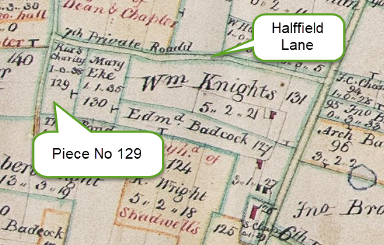
Second, and one other piece of land marked on the map hereto annexed No 129 [see below] containing one acre and thirty eight perches, bounded
– by the seventh Private Road2, North,
– by land allotted to Mary Eke, East,
– by land allotted to Thomas Pond, South, and
– by the sixth Private Road, West;
And we direct the said trustees of the Reverend Henry Rix‘s charity to make and keep in repair a fence in their second allotment against the allotment to Mary Eke.
1815 Survey
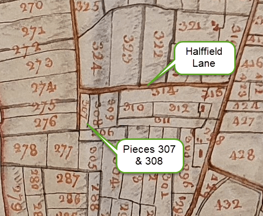
The 1815 survey shows two separate pieces, the total of which is 1 acre and 38 perches, as in the 1814 inclosures awards shown above. There is no mention of the Charter Acre title, although this is clearly the same field.
| Arable | Pasture | ||||||
| Reference | Description | Acres | Roods | Perches | Acres | Roods | Perches |
| 307 | Pightle | 2 | 38 | ||||
| 308 | Upper Grigson’s | 2 | 0 | ||||
1832 Letter from Curate
In a letter from the curate of the Parish, Rev. A.S. Warner, dated approximately to 1832, he wrote:-
It is stated in the Parish Terrier of 1820 that this legacy was laid out in land and by the award of the Commissioners on the Deopham Inclosures a. d. 16 July 1814 they set out to the Trustees of this Charity two pieces of land: one containing 4.1.32 and the other containing 1.0.38.
In the Terrier above mentioned that the 1.0.38 was incorrectly set out to the Trustees of Rix’s charity and that it had been intended to have been allotted in respect of a piece of land called Charter Acre the rents of which had been unintentionally applied in paying 11s/ annually to the Sheriff for renewing the Town Charter & the residue for the repairs of the church.
The Vicar and Churchwardens act as Trustees.
It would appear therefore that the payments to the Sheriff were disputed by the church.
1843 Tithe Analysis
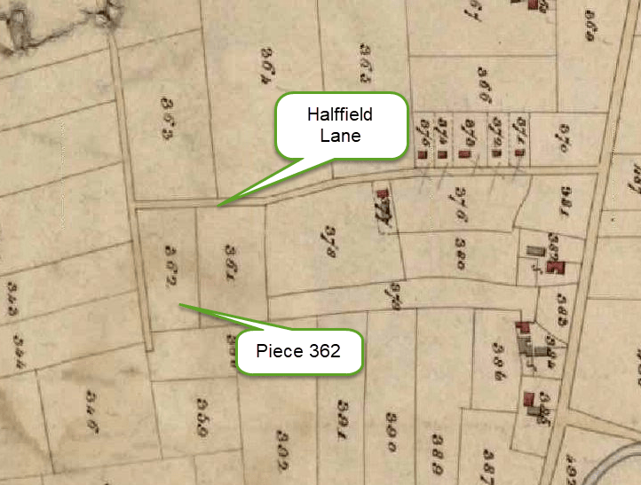
The size of the land is shown as 1 acre 1 rood & 15 perches, a slight increase on the 1814 & 1815 figure, and not a measurement that appears elsewhere.
| Map reference | Landowner | Occupier | Description | State of Cultivation | Quantity | Payable to Vicar | ||||
| a | r | p | s | d | ||||||
| 362 | Churchwardens & Overseers of Deopham | WRIGHT William | Charter acre | Arable | 1 | 1 | 15 | 11 | 7 | |

Directories
White’s 1836 Directory
No mention is made in this the oldest directory of the Charter Acre, nor the benefits derived from a Charter.
White’s 1845 Directory
The first directory mention of the Charter Acre appears in this directory published in 1845. This entry makes no suggestion that the Charter Acre is part of the Rix Charity lands. The size of the land quoted corresponds to the 1814 and 1815 analyses shown above. The text reads:
The Charter Acre was exchanged at the enclosure for 1A. 38P., let for 30s., of which 11s. is paid annually to the sheriff for renewing the “town charter,” and the residue is carried to the church rates.
Whites 1854 Directory
The Charter Acre, exchanged at the enclosure for 1a. 38p., let for £3, of which 11s. is paid annually to the sheriff, for renewing the “Town Charter,” and the remainder is applied with the church-rates.
White’s 1864 Directory
This is very similar to the 1845 directory entry, although this is the first time that there is a comment about the parishioners being exempt from serving on juries:
The Charter Acre was exchanged at the enclosure for 1a. 38p., let for £5, of which 11s. are paid annually, to the sheriff, for renewing the “town charter” which exempts the parishioners from serving on juries, and the residue is carried to the church rates.
Whites 1890 Directory
The Charter Acre is not mentioned after the 1864 Directory until the following entry in the 1890 Directory. The size of the Charter Acre is consistent with the 1814 & 1815 figure, but the use to which the income is put has changed.
The Charter Acre was exchanged at the enclosure for 1a. 38p., which constitutes the remuneration of the parish clerk.
Footnotes
- This first allotment subsequently became the playing fields. ↩︎
- i.e. Halffield Land as it is now called. ↩︎
| Date | Change |
|---|---|
| 7/6/26 | Published |
