Contents
- The Manor
- 1723 Observation
- 1769 Survey
- 1801 Construction of Barn
- 1807 Survey and Valuation of the Manor and Parsonage
- 1812 Enclosures
- 1814 Map
- 1815 Survey
- 1818 House decayed
- 1819 Tradesmen
- 1843 Map
- Post 1843
- 1883 O.S. Map
- 1897 Charles Hurrell became tenant
- 1916 – Kitchen Fire
- 1949 – Repairs to House and Outbuildings
- 1951 – Sale by the Church Commissioners
- 1992 – Planning application for extension
- 1993 – Further planning application
- 2000 – Sale of Property
- 2003 – Winter
- 2005 – Drawings of the Barn
- Occupants of Church Farm
- Footnotes
- Navigation
The Manor
From medieval times, Church Farm had been home to the Manor of Deopham of the Dean & Chapter of Canterbury. The land around the house was one of 34 pieces that made up the Manor. There are still many extant documents relating to the courts, surveys and leases of the Manor. There is more information on the Manor and its history here.
1723 Observation
In a letter written by the Rev. Henry Rix in 1723, the observation is quoted from the Lessee that at that time “the headhouse & Outhouses [are] covered with thatch & the Jackdaws & other birds lying much upon them.”
1769 Survey
The survey (Terrar) from 1769 describes what is now known as Church Farm, stating that the following buildings are “under one roof”:
- The Rectory House – about 50 feet in length and 18 feet at the end;
- at the east side a little room – tyled
- at the west side a Porch
- Backhouse – 33 feet long, 18 at the end
- Lodge or Turf House 18 feet X 18 feet
- Stable and Cowhouse 31 feet X 18 feet
All made of Clay Walls and Thatch except the little room.
There is also Barn 66 feet X 39 feet “much in decay in the Thatch – and Materials – shored up at west end”.
Full details of this terrar can be seen here.
1801 Construction of Barn
On January 9th 18021 Mr. Gilman, the solicitor for the Lessees of Church Farm, forwarded the following invoice to the Dean and Chapter of Canterbury. It had been presented by the builder, John Harwood. Mr Gilman says in this letter that the barn had been “completed last summer”; the builder consistently states that it had been “erected in 1801”. At 58 feet by 21 feet, the new barn was somewhat smaller than that recorded above in 1769 which was 66 X 39.
A minute in the Canterbury Chapter Acta Capituli for 1800 says that Chapter would pick up one third of the cost of constructing the barn, albeit on the basis of that cost being 100 guineas – considerably less than the invoiced cost.

Reproduced courtesy of the Chapter of Canterbury; their ref AL216
£176 in 1801 would be approximately £11,000 in 20232.
1807 Survey and Valuation of the Manor and Parsonage
This report includes “a Farm House, Barn and Stable chiefly Clay walls and Thatched, but in good repair.” No other buildings are listed.
1812 Enclosures
As part of the enclosure process, a plot of land owned by Bevil Amyas adjacent to Church Farm (called The Crofts) was swapped with land in the area of what is now Shaw’s Farm owned by the Dean and Chapter of Canterbury. The map below shows that this made good sense for both parties; the two plots being swapped are coloured in pink. The post enclosures 1814 map below indicates that the proposal indicated on this map was in fact carried out.
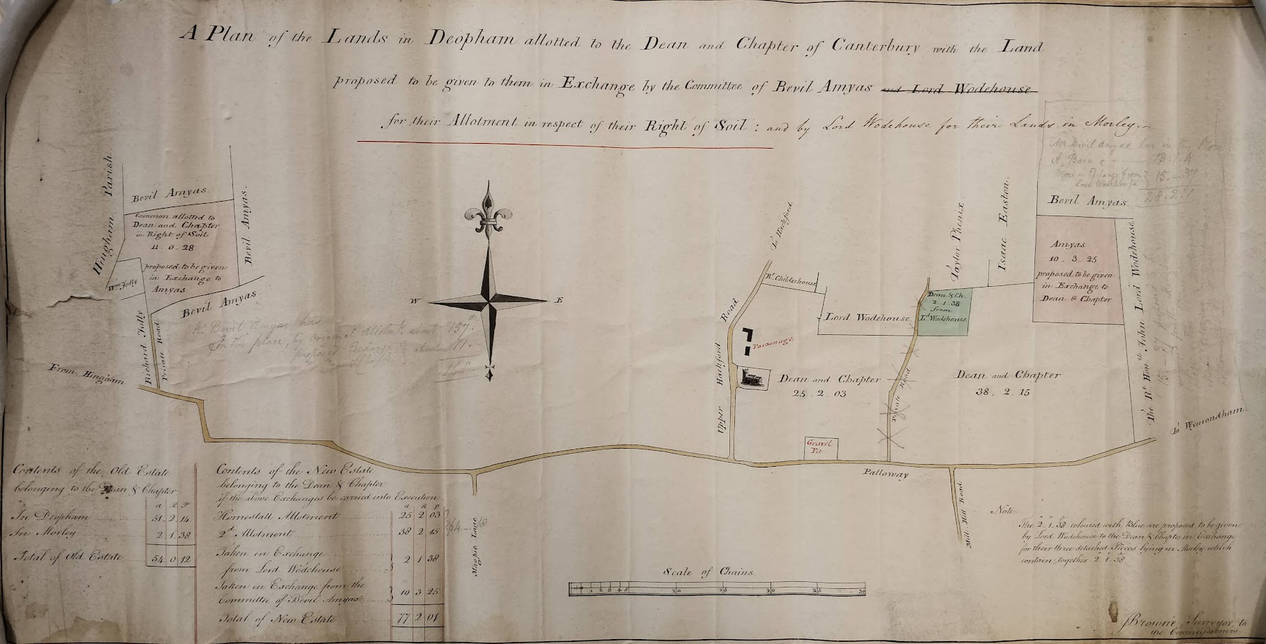
All rights reserved by Norfolk Record Office who hold the original; their ref is NRO MS 21873, 600X1
There is a title for this plan on the reverse:

All rights reserved by Norfolk Record Office who hold the original; their ref is NRO MS 21873, 600X1
1814 Map
Church Farm (or Manor Farm as it is called in some of the documents below) was that area of 64 acres, 0 roods and 18 perches shown on the map below as belonging to the “Dean & Chapter of Canterbury” plus the 10a 3r 25p acquired from Bevil Amyas during the Inclosures process.
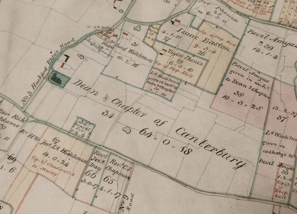
All rights reserved by Norfolk Record Office who hold the original; their ref is NRO C/Sca 2/86
1815 Survey
The 1815 survey of Deopham lists the pieces at that time which made up the Dean & Chapter of Canterbury’s property in Deopham. This totalled 65 acres of arable and 12 acres of pasture. The details are available here.
1818 House decayed
On May 18th 1818 Mr Gilman (solicitor to the lessees, the Misses Amyas) wrote to the agent of the Dean & Chapter at Canterbury as follows:
Hingham
18th May 1818
Dear Sir,
I beg to acquaint You for the Information of the Revd Dean & Chapter that the Roof of their Rectory House at Deopham was in part blown down by the late high Winds; and, upon a thorough Examination since, the House is ascertained to be in such a decayed State that the greatest Part of it must be rebuilt. Indeed it is now found to be dangerous to live in the House on account of the Chimneys, which are so decayed that it is surprising the House has not been burnt down.
In 1816 we expended on the Parsonage House £12, & £21. 18. 5 upon the Chancel and in last Year we expended upon the Parsonage £56.18.8.
The late Mischief and the State of the injured Part makes us wish to rebuild the Remainder with Brick and Tile, if the Dean & Chapter will have the Goodness to grant a proportionate Assistance to the Tenant. The further estimate amounts to £210.
That the Dean & Chapter may be aware of the Reasonableness of their Tenants’ Request, I thought it proper to state the Expenses already incurred: in Addition to which we are now required by the Archdeacon to new reed the Chancel, & to repair the Stone Work at the Gable End, which together we have Reason to fear will cost between £50 & £60 more.
Having stated the Facts by the Desire of the Misses Amyas, I am also directed by them to request you will lay the Statement before before the next Chapter, and to beg You will inform the Lessees afterwards (through me) of the Opinion & Intention of the Reverend Gentlemen on the Subject.
I am My Dear Sir,
Your very faithful Servant,
S. H. L. N. Gilman
Chapter of Canterbury Archive ref AL674
1819 Tradesmen
During the period 1811 to 1819, the affairs of Bevil Amyas, who held the lease on Church Farm, were managed by the Rev. Bence Bence. Bevil Amyas had been declared unfit to manage his own affairs. At the end of this period, the Rev. Bence Bence forwarded a detailed set of accounts listing his expenses in maintaining the farm. The originals of these accounts are reproduced here. The following table summarises the sums expended by the tenant, Garrett Oddin Taylor, in looking after the farm during the years of the Rev. Bence Bence’s trusteeship. All values are in £-s-d.
| Tradesman | Trade | |
|---|---|---|
| Haythorpe | Carpenter | £6-17-5½ |
| Fenix | Thatcher | £1-2-6 |
| Ward | Blacksmith | 16-11½ |
| Watson | Tiles | 12-6 |
| Barnes | Lime | 6-8 |
| – | Sand | 1-3 |
1843 Map
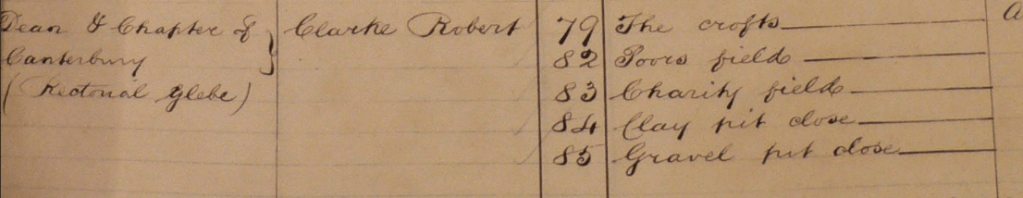
The pieces listed on this map correspond to the pieces shown in the 1843 tithe analysis as being occupied by Robert Clarke.
The list of references to the right of this plan shows by the brackets on the left hand side that pieces 75-81 are owned by B. Amyas Esq. and that 79-174 are owned by the Dean & Chapter of Canterbury.
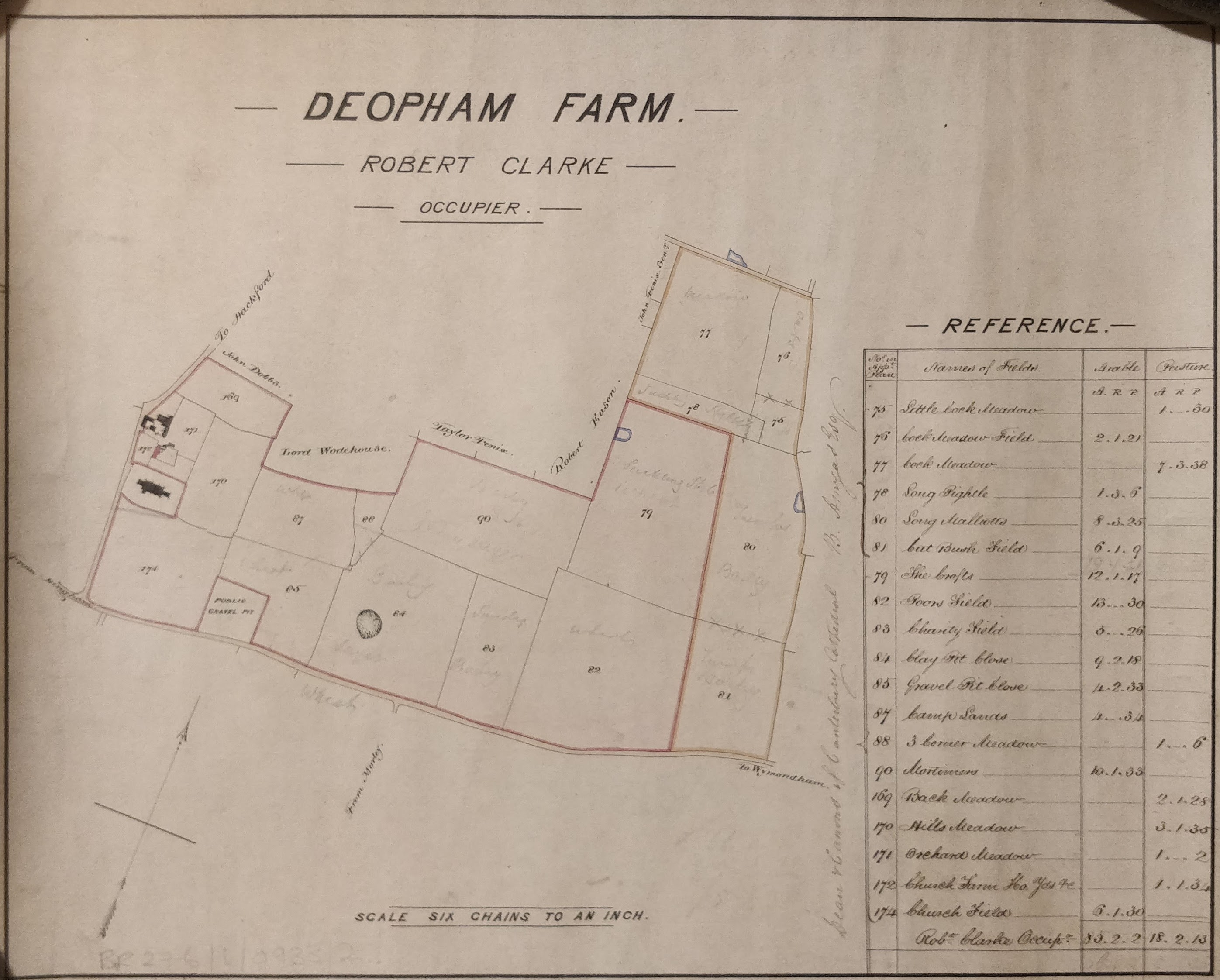
All rights reserved by Norfolk Record Office who hold the original; their ref is NRO BR 276/1/933/2
| No. on plan | Names of Fields | Arable | Pasture | Cultivation |
|---|---|---|---|---|
| A. R. P. | A. R. P. | |||
| 75 | Little Cock Meadow | 1.0.30 | Oats | |
| 76 | Cock Meadow Field | 2.1.21 | Oats | |
| 77 | Cock Meadow | 7.3.38 | Meadow | |
| 78 | Long Pightle | 1.3.6 | Suckling | |
| 80 | Long Malliotts | 8.3.25 | Barley | |
| 81 | Cut Bush Field | 6.1.9 | Turnips/Barley | |
| 79 | The Crofts | 12.1.17 | Wheat | |
| 82 | Poors Field | 13.0.30 | Wheat | |
| 83 | Charity Field | 5.0.26 | Barley | |
| 84 | Clay Pit Close | 9.2.18 | Barley layer | |
| 85 | Gravel Pit Close | 4.2.33 | Wheat | |
| 87 | Camp Lands | 4.0.34 | Wheat | |
| 88 | 3 Corner Meadow | 1.0.6 | Barley | |
| 90 | Mortimers | 10.1.33 | Barley new layer | |
| 169 | Back Meadow | 2.1.28 | ||
| 170 | Hills Meadow | 3.1.35 | ||
| 171 | Orchard Meadow | 1.0.2 | ||
| 172 | Church Farm House, Yards, etc | 1.1.34 | ||
| 174 | Church Field | 6.1.30 | ||
| Totals | Robert Clarke Occupier | 85.2.2 | 18.2.13 |
Land owned by Bevil Amyas but farmed by Robert Clarke:
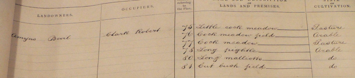
All rights reserved by Norfolk Record Office who hold the original; their ref is NRO PD 485/28
Land owned by the Dean & Chapter of Canterbury but farmed by Robert Clarke:

All rights reserved by Norfolk Record Office who hold the original; their ref is NRO PD 485/28
Post 1843
Although not showing the school, the land taken from the farm for the school is marked off from field no 171. This separation occurred in 1850.


| Nos on plan | Names of Fields | Arable A. R. P | Pasture A. R. P |
|---|---|---|---|
| 79 | The Crofts | 12.1.17 | |
| 82 | Poors Field | 13.0.30 | |
| 83 | Charity Field | 5.0.26 | |
| 84 | Clay Pit Close | 9.2.18 | |
| 85 | Gravel Pit Close | 4.2.33 | |
| 87 | Camp Lands | 4.0.34 | |
| 88 | 3 Corner Meadow | 1.0.6 | |
| 90 | Mortimers | 10.1.33 | |
| 169 | Back Meadow | 2.1.28 | |
| 170 | Hills Meadow | 3.1.35 | |
| 171 | Orchard Meadow | 1.0.2 | |
| 172 | Church Farm House | 1.1.34 | |
| 174 | Church Field | 6.0.30 | |
| Totals | 65.3.21 | 9.1.25 |
All rights reserved by Norfolk Record Office who hold the original; their ref is NRO BR 276/1/933/1
Another copy of the above map held at the Norfolk Record Office shows “Church Farm House” changed to “Manor Farm House” implying the possibility that the “Manor” title is the later attribution.

1883 O.S. Map

1897 Charles Hurrell became tenant
In February 1897 Charles Hurrell, realising that his situation as leaseholder of Mary Ann Rowing at Laurel Farm was precarious, applied to the Ecclesiastical Commissioners to take on the lease of Church Farm. In this, he was supported by the vicar, the Rev. J.S. Treglown who wrote a reference in his favour.
A letter from the agents dated November 1897 addressed to the Ecclesiastical Commissioners indicated that the current tenant, a Mr. F. Smith, had been in difficulties and had vacated the farm at Michaelmas (September 29th) that year. They stated also that they had accepted Mr. Charles Hurrell as tenant from that date. He did not have to vacate Laurel Farm until Michaelmas 1901.
1916 – Kitchen Fire
In 1916 a fire in the kitchen necessitated repairs, details of which are here. C. Hurrell was the tenant at this time.
1949 – Repairs to House and Outbuildings
In January 1949 the Church Commissioners were asked to approve repairs and improvements to the house and outbuildings. These are detailed here.
1951 – Sale by the Church Commissioners
In 1951 Church Farm was sold by the Church Commissioners to Mr. Geoffrey Liddelow Peacock for £3,400. The details of this process are recorded here.
1992 – Planning application for extension
A planning application was submitted on August 10th 1992 for the “Erection of porch, conservatory, covered way and erection of new garage/workshop”. This was approved on September 7th 1992. The documentation for this application is no longer available.
1993 – Further planning application
Another planning application was submitted on February 3rd 1993 for the “Erection of extensions to dwelling”. This was approved on April 6th 1993. The documentation for this application is no longer available.
2000 – Sale of Property
In 2000 Denis and Gloria Lee put the house on the market: there is a copy of the sales particulars here.
2003 – Winter

Photo: G. Sankey, 1/2003
2005 – Drawings of the Barn

Occupants of Church Farm
| Years | Occupant | Source of information |
|---|---|---|
| 1849 | Robert Clarke | 1849 Letter from Rev. Henry Spencer to the Dean of Canterbury dated 26/4/1849. Lease due to expire Michaelmas [i.e. September] next. |
| 1852 | Philip Salter Millard | 1852 Register of Electors |
| 1863-1874 | George & Anna Maria Millard | 1863 letter from C.W. Millard (brother of George) to Ecclesiastical Commissioners dated 24/6/1863 1874 Register of Electors See also Register of Baptisms, entry for 9/8/1874 |
| 1897 | Charles Hurrell | Letter from agents |
| F. T. M. Hurrell | ||
| Mr. & Mrs. Wood | Michael Allen | |
| Philip Curl and Nicola née Gurney | Michael Allen | |
| – 2000 | Dennis & Gloria Lee |
Footnotes
- Mr. Gilman actually wrote “1801”, but the date stamp embossed at Canterbury says 1802, and the filing annotation also says 1802 – see here. ↩︎
- Using the Bank of England Inflation Calculator:
https://www.bankofengland.co.uk/monetary-policy/inflation/inflation-calculator ↩︎
Navigation
| Date | Change |
|---|---|
| 8/9/25 | Link to 2000 sales particulars |
| 30/6/25 | 1992 & 1993 planning applications |
| 28/5/25 | Tabulated 1843 field names |
| 31/3/25 | 1916 Kitchen Fire, 1941 repairs & sale by Church Commissioners |
| 19/4/24 | Improved Clarke plan; table of fields & crops |
| 15/4/24 | Hurrell application |
| 9/3/24 | Link to 1769 terrar |
| 27/2/24 | 1819 tradesmen |
| 5/1/24 | Link to Henry Rix letter of 1723 |
| 31/12/23 | 2005 drawings of barn |
| 5/12/23 | Deopham Manor |
| 29/11/23 | 1811 Construction of Barn; 1818 decay |
| 23/11/23 | Updated table of occupants |
| 4/11/23 | 1883 O.S. Map |
| 2/11/23 | Table of occupants |
| 14/9/23 | Map of land swapped between Bevil Amyas and D & C of Canterbury |
| 25/8/23 | Published |
