Contents
- Introduction
- Map of Church of England Mining and Mineral Rights in Deopham
- Information on the plots
- Postscript – Church Farm
- Footnotes
- Credit
- Navigation
Introduction
The 1894 Copyhold Act gave Copyhold tenants the right to buy out their copyhold obligations to the Lord of the Manor. The Lords of the Manor of the Manor of Deopham of the Dean and Chapter of Canterbury had been the Ecclesiastical Commissioners since 1862 (see here for more information on this transfer). They were succeeded in 1948 by the Church Commissioners who inherited all the rights and assets of the Ecclesiastical Commissioners.
This 1894 Act allowed the Lords of the Manors to retain mining and mineral rights as detailed in “Section 23“; generally however the Lords in Deopham (both ecclesiastical and secular) waived this right and the copyholders were assigned unfettered freehold of their land – in return for a payment.
The Land Registration Act of 2002 required all reserved manorial rights to be registered by October 13th 2013: the Church of England filed 5,773 claims across the UK in the eight years leading up to 2013. In a parliamentary submission written in 20181, the Church of England estimated its manorial mineral ownership extended to approximately 300,000 acres of land. The acreage of land above ground was 105,000 acres.
Although the Church has claimed the mines and minerals beneath the land, unless specifically stated in the entry at the Land Registry, they do not have the right to break the surface of the land in order to work the mines and minerals.
In Deopham, the Church of England’s rights extended, and still exist in 2025, to six plots making up a total of 42 acres:-
| Plot No on 1814 Map | Land Registry Descriptions | Acreage (a – r – p) |
|---|---|---|
| 139 | Land on the north and west sides of Halffield Lane, Deopham Green | 14-1-9 |
| 141 | Land on the north and west sides of Halffield Lane, Deopham Green | 2-3-0 |
| 154 | Land lying to the south west of The Stalland, Deopham | 11-2-39 |
| 155 | Land lying to the south west of The Stalland, Deopham | 0-3-6 |
| 157 | Land lying to the south west of The Stalland, Deopham | 1-2-27 |
| 163 | Land lying to the east of The Stalland, Deopham | 10-3-5 |
| Total | 42-0-6 |
These six plots are best identified on the 1814 map as shown below because roads and boundaries moved during and after the construction of the airfield. Plots 154 & 155 are shown as a single entity on the Land Registry entry.
Map of Church of England Mining and Mineral Rights in Deopham
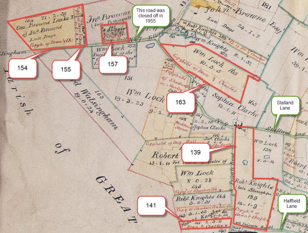
All rights reserved by Norfolk Record Office who hold the original; their ref is NRO C/Sca 2/86
Information on the plots
Piece no 139 (Walnut Tree Farm)
Enfranchisement
At the Court of the Manor of the Dean & Chapter of Canterbury held on October 7th 1909, the enfranchisement of this piece of land, which had taken place on December 19th 1901, was recorded with a full copy of the agreement. This included the following exclusion, which along with piece no 141 below specifically references coal:
Except and reserved unto the Lords, their successors and assigns all mines, beds and veins of minerals, coal, clay, plate, stone and other substances and substrata within and under the hereditaments hereby granted, or any part thereof, lying below a distance of Two hundred feet from the surface thereof.
Land Registry Entry
All mines beds and veins of minerals clay slate stone and other substances and substrata lying below a distance of 60.96m (200 feet), excluding any mines and minerals which vested in the Coal Authority pursuant to the Coal Act 1938.
Land Registry Plan
The two areas enclosed in red are those over which the Church Commissioners retain mining and minerals rights in 2025:-
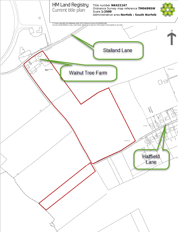
© Ordnance Survey
Piece no 141
Enfranchisement
Pieces 139 & 141 were two separate entities in the records of the Courts of the Dean & Chapter of Canterbury, but are now combined in the Land Registry filing as a single entity.
The Enfranchisement of piece no 141 was registered at the Court of the Manor of the Dean & Chapter of Canterbury held on October 7th 1909, although the Deed of Enfranchisement for this piece of landis dated December 19th 1901. This included the following exclusion, which (along with piece no 139 above) specifically references coal:
Except and reserved unto the Lords, their successors and assigns all mines, beds and veins of minerals, coal, clay, plate, stone and other substances and substrata within and under the hereditaments hereby granted, or any part thereof, lying below a distance of Two hundred feet from the surface thereof.
Piece no 154
Enfranchisement
Pieces 154 & 155 were two separate entities in the records of the Courts of the Dean & Chapter of Canterbury, but are combined in the Land Registry filing as a single plot.
There is no record in the Court Rolls of the enfranchisement of this land.
Land Registry Entry
All mines minerals and mineral substrata situate at a greater depth than 60.96m (200 feet) from the surface (excluding any mines and minerals which vested in the Coal Authority pursuant to the Coal Act 1938).
Land Registry Plan
The two areas enclosed in red are those over which the Church Commissioners retain mining and minerals rights in 2025; these three pieces used to abut the road to Ellingham, but since this road was moved in 1955 to run along the old runway these pieces have been left with no obvious boundaries on the ground. Although they protrude into Hingham, they actually lie within the Deopham parish boundary.

© Ordnance Survey
Piece no 155
Enfranchisement
Pieces 154 & 155 were two separate entities in the records of the Courts of the Dean & Chapter of Canterbury, but are combined in the Land Registry filing.
There is no record in the Court Rolls of the enfranchisement of this land. However, there is an Indenture dated April 13th 1923 between Helen Gertrude Phoenix and Walter Charles Phoenix concerning pieces 155, 157 and 180 which includes the following “Whereas” section which refers to enfranchisement having taken place on April 12th 1923:
AND WHEREAS by an Indenture dated the twelfth day of April, One thousand nine hundred and twenty three and made between
– The Ecclesiastical Commissioners for England, Lords of the said Manor of Deopham of the Dean and Chapter of Canterbury of the one part and
– the said Helen Gertrude. Phoenix of the other part
for the consideration therein mentioned, the said hereditaments copyhold of the said Manor of Deopham of the Dean and Chapter of Canterbury were granted, enfranchised, released and conveyed unto the said Helen Gertrude Phoenix in fee simple, In trust for the said Walter Charles Phoenix his heirs and assigns as freehold thenceforth and for ever discharged from all fines, quit rents, heriots and other incidents of copyhold or customary tenure
Land Registry Entry
All mines minerals and mineral substrata situate at a greater depth than 60.96m (200 feet) from the surface (excluding any mines and minerals which vested in the Coal Authority pursuant to the Coal Act 1938).
Piece no 157
There is no record in the Court Rolls of the enfranchisement of this land, but see above under piece 155 for reference to an indenture relating to the enfranchisement of piece 157.
Land Registry Entry
All mines minerals and mineral substrata situate at a greater depth than 60.96m (200 feet) from the surface (excluding any mines and minerals which vested in the Coal Authority pursuant to the Coal Act 1938).
Piece no 163
At the Court of the Manor of the Dean & Chapter of Canterbury held on October 7th 1909, the enfranchisement of this piece of land, which had taken place on July 11th 1907, was recorded with a full copy of the agreement. This included the following exclusion:
Excepting nevertheless and reserving to the Lords (the Tenant also hereby granting and releasing to them) and their successors and assigns all mines and minerals with the mineral or substrata lying and being within or under (and situate at a greater depth than Two hundred feet from the surface of) the said copyhold hereditaments hereinbefore expressed to be hereby conveyed or enfranchised;
Together with full power to win and work, get and carry away by any methods of mining which shall for the time being be in ordinary use in the District or otherwise recognised as a proper way of working mines, but without entering upon the surface of the said hereditaments or of the buildings for the time being thereon.
Land Registry Entry
All mines and minerals with the mineral substrata lying and situate at a greater depth than 60.96m (200 feet) from the surface, excluding any mines and minerals which vested in the Coal Authority pursuant to the Coal Act 1938.
Land Registry Plan
The area enclosed in red is that over which the Church Commissioners retain mining and minerals rights in 2025.
Note: Stalland Lane has been straightened since the time of the enfranchisement in 1907 leaving the road separated from the land over which the Church Commissioners have their rights. There is an image showing the 1906 road layout overlaid on a 2025 satellite view here.
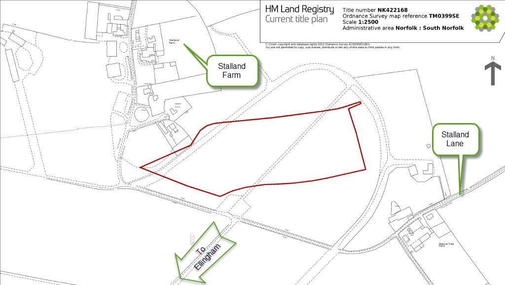
© Ordnance Survey
Postscript – Church Farm
When Church Farm was sold by the Church Commissioners in 1951, there was initially a proposal to retain the rights to minerals. However, having been persuaded that there were none, this clause was dropped. The details of this discussion are available here.
Footnotes
Credit
I am indebted to Guy Shrubsole who has done invaluable work in identifying the assets of the Church of England.
Navigation
| Date | Change |
|---|---|
| 4/8/25 | Link to Ecclesiastical Commissioners |
| 15/4/25 | Note on Church Farm with links |
| 14/4/25 | Published |
