Comments
- This was a huge Court, applying all the declarations of the Inclosures Commission relevant to the Manor’s Copyhold lands. Only the first transaction (the surrender by Joseph Say) can be considered routine business.
- No fines were imposed; rents in every case were to be “subject to the same Charges and by and under the same Rents, Customs and Services as the said Copyhold Premises were held”.
- Generally plots before the inclosure process had been measured “by estimation”; as a result there are slight variations between the existing copyhold dimensions and those of the Inclosures Commission.
- All of the Deopham Manor copyhold pieces identified by the Inclosure Commission were transacted in this court.
- The Manor of Deopham Hall held a similar Court on the same day to review all of their Copyhold lands. The Manor of Shadwells otherwise Cockerells held theirs on August 18th 1814.
Contents
- Heading
- Homage
- Property
- Inclosure map extracts
- The location of piece no 155
- The location of piece no 8
- Location of piece no 75
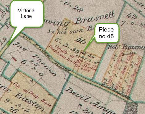
- Location of piece no 45
- Location of pieces nos 159 & 160
- Location of piece no 80
- Location of piece no 172
- Location of pieces nos 87, 92 & 97
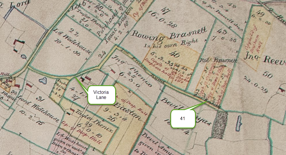
- Location of piece no 41
- Location of piece no 63
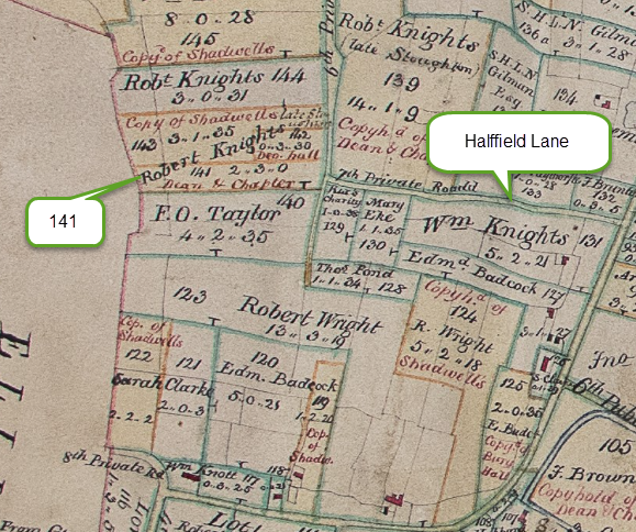
- Location of piece no 141
- Location of piece no 182
- Location of piece no 139
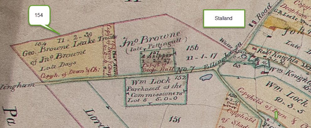
- Location of piece no 154
- Location of piece no 105
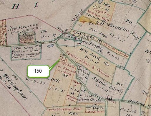
- Location of piece no 150
- Location of piece no 163
- Location of piece no 157
- Location of all Dean & Chapter Pieces
- Navigation
Heading
| Title | Deopham of the Dean and Chapter of Canterbury: A General Court |
| Date | April 7th 1814 |
| Steward | Samuel Heyhoe Le Neve Gilman, Deputy Steward of Samuel Gilman Chief Steward |
| Location | “In the said Manor” |
| Page numbers in Court Roll | 99-137 |
Homage
| Robert Knights |
| Rowing Brasnett |
| John Dobbs |
Property
| Person surrendering property | Date of the Copyhold | Beneficiary | Attorney | Identification of property |
|---|---|---|---|---|
| Joseph Say | February 2nd 1814: before William Rackham Deputy Steward Out of Court surrender to the Lord of the Manor to the Uses of his Last Will & Testament | All and every the Messuages, Lands, Tenements and Hereditaments whatsoever | ||
| Charles Allen (deceased) | December 29th 1778 after the death of Charles Allen, his father | Charles Allen (son) | Moiety or part of a Messuage Parcel of the Tenement Browne in Whoolwhite or Stalland Street, namely the East part of the Messuage. | |
| (Inclosure Commissioners) | Charles Allen (son) | Himself | 14 perches with a messuage – Piece no 106 on Inclosures map [this piece is 8 acres near the Mill so there appears to be an error; it is most likely intended to be piece 160 (see below) which is on the Stalland] bounded by Robert Knights North; William Lock East; Surveyors of the Highways South; Abraham Skipper the Younger, West. | |
| (Inclosure Commissioners) | Charles Allen (son) | Himself | 3 roods & 6 perches – Piece no 155 on Inclosures map (see below) – bounded by Parish of Hingham North-West; John Browne North-East; Ellingham Road South-East; George Browne Leake South-West. | |
| John Amyas (deceased) | November 15th 1804 | Bevil Amyas as eldest brother | 5 roods in 3 pieces; formerly belonging to Robert Knights | |
| (Inclosure Commissioners) | Bevil Amyas | Daniel Alexander the younger | 1 acre, 1 rood & 14 perches – No 8 on Inclosures map (see below) – bounded by Bevil Amyas East; Wymondham Rd or Palloway South; Bevil Amyas West and North. | |
| (Inclosure Commissioners) | October 26th 1810 under the will of John Jolly (deceased) | Rowing Brasnett of Deopham, farmer | Himself | Before Inclosure: 1) 3 roods of Copyhold land, late part of Tenement Browne’s at Bulls Wood in Deopham between Lands late of Robert Cock, South; Lands formerly of Ismael Bubbyn, North; Church Way, West ; 2) 1 rood of Copyhold land in Church Field in Deopham between Lands late of John Smith, East & West; the long Headland, South. Total: 1 acre. After Inclosure: 1) 1 acre & 5 perches – no 75 on the Inclosures map (see below) – bounded by Rowing Brasnett land, North , East & South; Attleborough Rd, West. 2) 1 rood & 14 perches – no 45 on the Inclosures map (see below) – bounded by Rowing Brasnett land, North & East; Second private road, South. Total: 1 acre, 1 rood & 19 perches |
| Henry Brasnett (deceased) | November 11th 1802 | Rowing Brasnett as eldest son | 1 Acre & 1 rood lying in 2 pieces + 2 acres called Cuffes in the West Field | |
| (Inclosure Commissioners) | Rowing Brasnett | Himself | 3 acres 2 roods & 32 perches – no 80 on the Inclosures map (see below) – Rowing Brasnett North; John Browne in part West; Attleborough Rd remaining part of West; Rowing Brasnett as Trustee South. | |
| (Inclosure Commissioners) | Rowing Brasnett | Himself | 1 acre & 2 roods – no 41 on the Inclosures map (see below) – Robert Brasnett as Trustee North & East & West; Second Private Road South | |
| John & Mary Buckle | December 8th 1806 | John Dobbs | 1 acre | |
| (Inclosure Commissioners) | John Dobbs | Himself | 1 acre 27 perches – no 172 on the Inclosures map (see below) – bounded by Wymondham Rd or Palloway North; John Dobbs North, South & West. | |
| Thomas Robinson | November 19th 1801 | George Denny Graver of South Creake as Trustee of John Browne | 3 roods of pasture | |
| (Inclosure Commissioners) | George Denny Graver of South Creake as Trustee of John Browne | Daniel Alexander the Younger | 3 roods & 22 perches – no 97 on the Inclosures map (see below) – bounded by Joseph Say North; 10th allotment to John Browne East & South; George Browne Leake South; Fourth Private Road in part West. | |
| John Bousell (deceased) | November 11th 1802 | Thomas Kett, Thomas Back & William Hart | 1½ acres in Church Field | |
| (Inclosure Commissioners) | Thomas Kett & Thomas Back (William Hart being dead) | Daniel Alexander the Younger | 1 acre 3 roods 3 perches – no 63 on the Inclosures map (see below) – bounded by Wymondham Rd or Palloway South; Thomas Kett & Thomas Back on all other parts | |
| Edward Clarke | December 21st 1797 | Robert Knights | One tenement called Brown’s with a Barn, in Woolwyte, otherwise Stalland Street, containing 1 acre + 2 acres & 1½ rood | |
| (Inclosure Commissioners) | Robert Knights | Himself | 2 acres & 3 roods – no 141 on the Inclosures map (see below) – bounded by the Third & Fourth Allotments to Robert Knights North; the Sixth Private Road East; Francis Oddin Taylor South; Parish of Gt Ellingham West. | |
| (Inclosure Commissioners) | Robert Knights | Himself | 3 acres, 1 rood & 10 perches – no 182 on the Inclosures map (see below) – with a Cottage bounded by John Browne North; William Lock, Charles Allen, Abraham Skipper, East; William Knights and Surveyor of the Highways South; Ellingham Rd West. | |
| Robert Stoughton | April 22nd 1805 | Robert Knights | 1 Messuage in Narrow Gate Street + 5 acres in 4 pieces + Wren’s Pightle + A croft adjoining containing 2 acres & 2 roods | |
| (Inclosure Commissioners) | Robert Knights | Himself | 14 acres 1 rood & 9 perches with a messuage & other buildings – no 139 on the Inclosures map (see below) – bounded by Stalland Rd North; William Lock and Samuel Heyhoe Le Neve Gilman East; Seventh Private Road South; Sixth Private Road West. | |
| Jonathan Dey (deceased) | December 10th 1807 | George Browne Leake of Holt in trust for John Browne of Tacolnestone | 4 acres arable land + 1 acre & 1 rood in 2 pieces in East Field + 1 acre in 2 pieces + 1 rood pasture + 1½ acres + ½ acre | |
| (Inclosure Commissioners) | George Browne Leake of Holt in trust for John Browne of Tacolnestone | Daniel Alexander the Younger | 11 acres 2 roods & 39 perches – no 154 on the Inclosures map (see below) – bounded by Hingham North-West; Charles Allen North-East; Ellingham Rd South-East; Gt Ellingham South-West. | |
| James Sparkhall | November 24th 1808 | George Browne Leake | 2½ acres pasture in Hill Field + 2 acres in Haughfield called Grimsmeer + 1 acre near the above 2 acres + 3 roods in the aforesaid field + ½acre called Scotts Pightle with a house | |
| (Inclosure Commissioners) | George Browne Leake in trust for John Browne | Daniel Alexander the Younger | 8 acres 3 roods – no 105 on the Inclosures map (see below) – bounded by Morley Rd North; John Browne & George Browne Leake East; George Hubbard South; Attleborough Rd West. | |
| John Buckle | November 24th 1808 | George Browne Leake in trust for John Browne | 1 acre in Church Field + 1 rood near Baleham Falgate | |
| (Inclosure Commissioners) | George Browne Leake in trust for John Browne | Daniel Alexander the Younger | 1 acre, 1 rood & 35 perches – no 92 on the Inclosures map (see below) – bounded by Fourth Private Road North; George Denny Graver & John Browne East; John Browne South; George Browne Leake West. | |
| Thomas Grigson Payne, esquire | February 20th 1797 | William Lock of Reymerstone, Farmer | Before Inclosure 2 acres & 1 rood in Deopham 1 acre 3 roods in Deopham 3 roods in Deopham in West Field 1 acre with void Messuage 3 roods in West Field 2 acres & 2½ roods After Inclosure 1) 2 roods & 17 perches – piece no 150 on the Inclosures map (see below) – bounded by Stalland Rd, North; William Lock, East, South & West. 2) 10 acres, 3 roods & 5 perches – no 163 on the Inclosures map (see below) – bounded by William Knights North-West; William Lock & Sophia Clarke East; Sophia Clarke & James Clarke South; Stalland Road South-West. | |
| James Garthon (deceased) | November 19th 1801 | Joseph Say | 2 roods called Morley Pightle in Deopham | |
| (Inclosure Commissioners) | Joseph Say | Daniel Alexander the Younger | 2 roods & 18 perches: piece no 87 on the Inclosures map (see below) – bounded by Fourth Private Rd West; Joseph Say North, East & South. | |
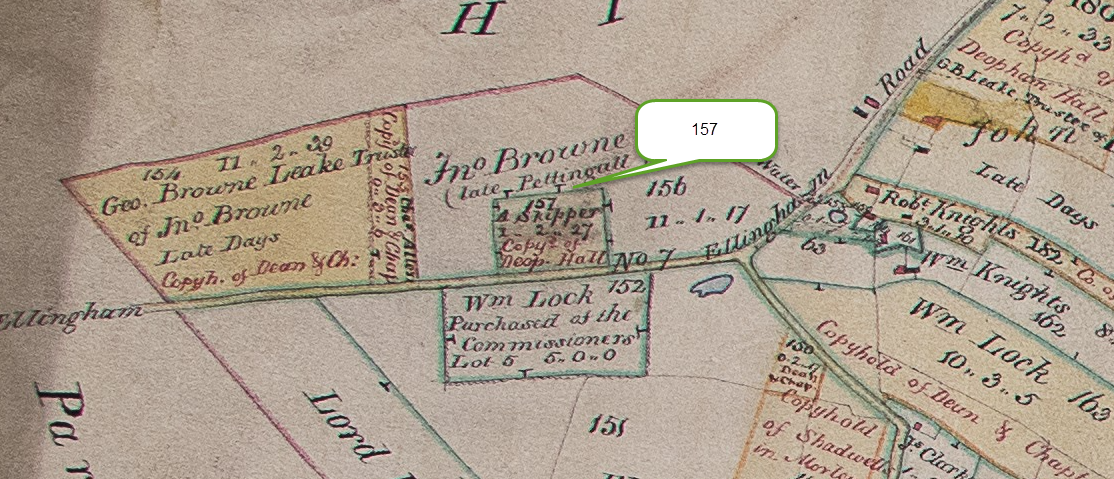
| Robert Clarke (deceased) via Garrett Oddin Taylor as Executor | October 26th 1813 | Abraham Skipper the Younger, Carpenter | Moiety of a House Parcel of the Tenement Browns | |
| (Inclosure Commissioners) | Abraham Skipper the Younger | 2 perches with a cottage – no 159 on the Inclosures map (see below) – bounded by Robert Knights & Surveyors of the Highways West; Robert Knights North; Charles Allen East; Surveyors of the Highways South. | ||
| (Inclosure Commissioners) | Abraham Skipper the Younger | Garrett Oddin Taylor | 1 acre, 2 roods & 27 perches – no 157 on the Inclosures map (see below) – bounded by Ellingham Rd South-East; John Browne all other parts. [Although labelled as Deopham Hall on the map, the accompanying text assigns this piece to Deopham Manor.] |

Inclosure map extracts
These are arranged in the same order as the table above.
The location of piece no 155

The location of piece no 8

Location of piece no 75

Location of piece no 45
Location of pieces nos 159 & 160

Location of piece no 80

Location of piece no 172

Location of pieces nos 87, 92 & 97

Location of piece no 41
Location of piece no 63

Location of piece no 141
Location of piece no 182

Location of piece no 139

Location of piece no 154
Location of piece no 105

Location of piece no 150
Location of piece no 163

Location of piece no 157
Location of all Dean & Chapter Pieces
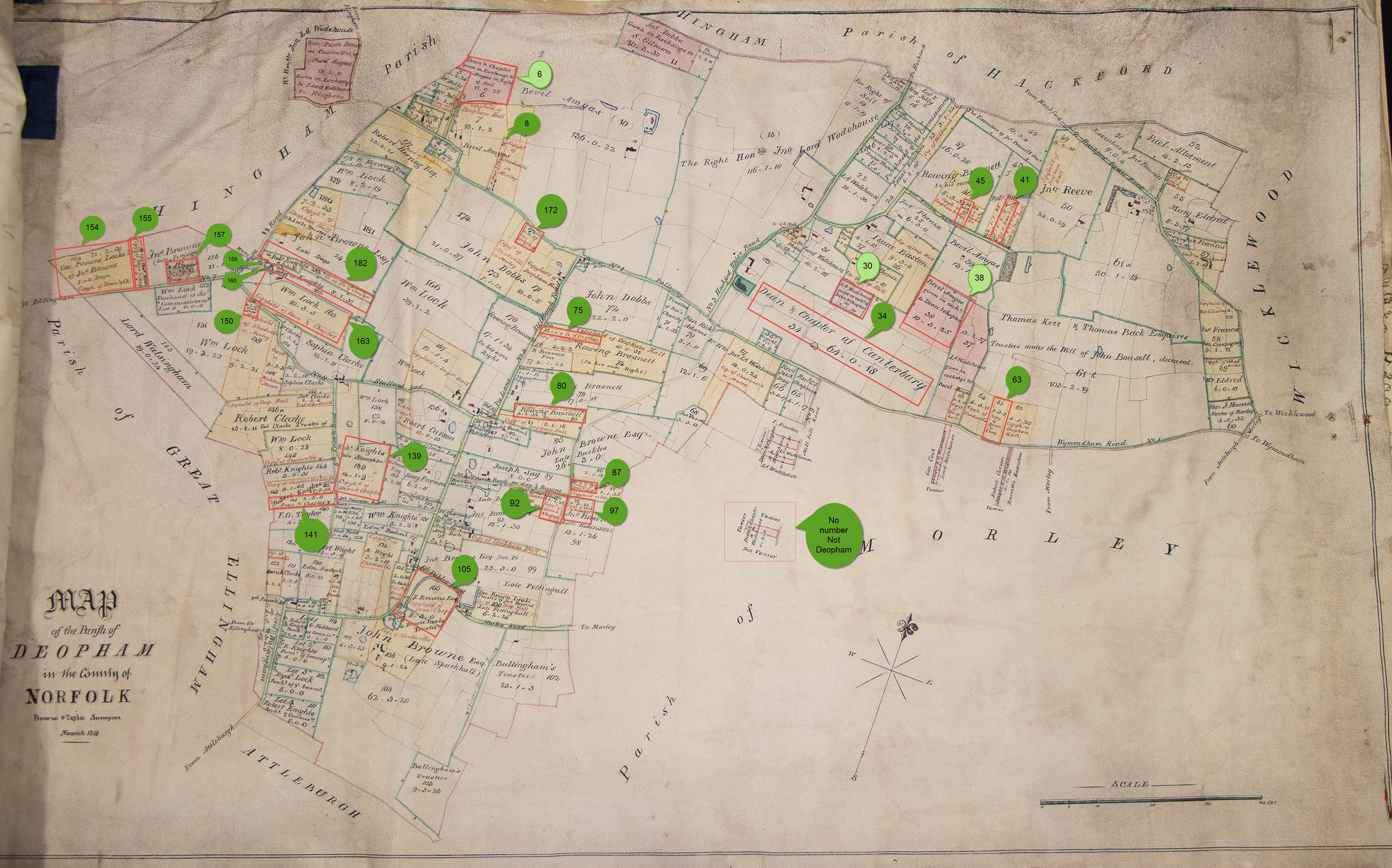
All rights reserved by the Norfolk Record Office who hold the original of the 1814 map used in all the above extracts; their ref is NRO C/Sca 2/86
Navigation
| Date | Change |
|---|---|
| 27/1/85 | Revised Rowing Brasnett |
| 24/1/25 | Reviewed against Court Book – 20250108_124550 |
| 10/4/24 | Published: ref IMG_20231012_144000 |
