also known as
Stalland Farm
(even though there is another called The Stalland Farm just down the road, and a third one on the other side of the road), and
Deopham Apiaries, The Stalland
Contents
- 1814 Enclosures Map
- 1815 Survey of Deopham
- 1843 Tithe Map
- 1850 building work
- 1895 Auction
- 1924 Arthur Long tenancy
- 1940s
- 1941 Farm Survey
- 1983 Photo
1814 Enclosures Map
The following extract from the 1814 post-enclosures map shows the present Red Brick Farm building on piece 162, occupied by William Knights.
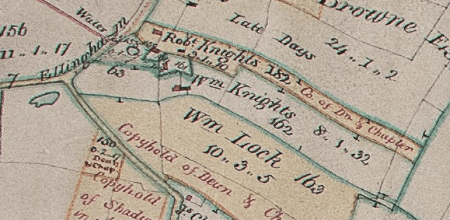
The analysis attached to the 1814 enclosures map states that piece 162 contains “eight acres one rood and thirty two perches with a messuage and other buildings standing thereon with land allotted to the surveyors of the Highways in part north, by land allotted to William Lock in part east in further part north and in part west by land allotted to Robert Knights on the remaining parts of the north and west by other land allotted to the said William Lock on the remaining part of the East and wholly south by the Stalland Road south west and by the Ellingham Road north west”.
1815 Survey of Deopham
The following is extracted from the map of the 1815 Survey of Deopham:
Reproduced courtesy of the Chapter of Canterbury; their ref 183720-17
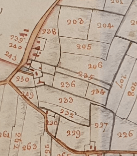
The accompanying analysis shows that, at that time, the following pieces were owned by William Knights and occupied by Daniel Knights (see further here):
| Arable | Pasture | ||||||
| Reference | Description | Acres | Roods | Perches | Acres | Roods | Perches |
| 234 | A Pightle | 2 | 6 | ||||
| 236 | Home Piece | 3 | 1 | 35 | |||
| 247 | A Pightle | 3 | |||||
| 248 | House, Barn and Garden | 1 | 5 | ||||
| 250 | Common Allotment | 1 | 3 | 26 | |||
| Totals | 7 | 0 | 27 | 1 | 5 | ||
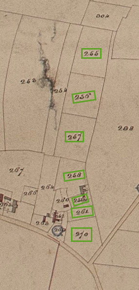
1843 Tithe Map
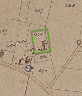
The present Red Brick Farm corresponds to the property on pieces 259 and 258 (outlined in green) on this plan extracted from the 1843 tithe map.
(The blue circle is the gravel pit/pond.)
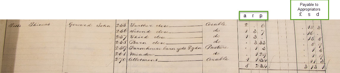
The analysis attached to the 1843 tithe map shows the above two plots to be part of a larger holding owned by Phineas Pitts and occupied by John Goward. The whole farm totalled 8 acres 2 roods and 34 perches:-
All rights reserved by Norfolk Record Office who hold the original; their ref is NRO DN/TA 743
The seven pieces listed in the above analysis can be identified on the accompanying tithe map as follows:-
All rights reserved by Norfolk Record Office who hold the original; their ref is NRO DN/TA 743
1850 building work
The following plaque was built into a chimney on the end of this house, probably when modifications were being done to the property, rather than during the original construction. The plaque had to be removed when the chimney was rebuilt and is now incorporated into the end gable of the garage.
The P.P. almost certainly refers to Phineas Pitts who is shown on the above 1843 Tithe map and analysis as being a landowner of property on the Stalland. It would appear from the Court Roll of the Manor of Shadwells otherwise Cockerells for May 18th 1876 that there were two men named Phineas Pitts – father and son, and that the son died before the father.
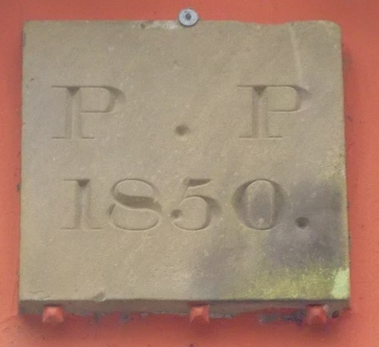
With thanks to Steve Mahoney for this photo.
1895 Auction
This auction on July 1st 1895 shows a property of 3 acres, 1 rood and 10 perches being sold as lot 12 of 13:
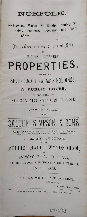
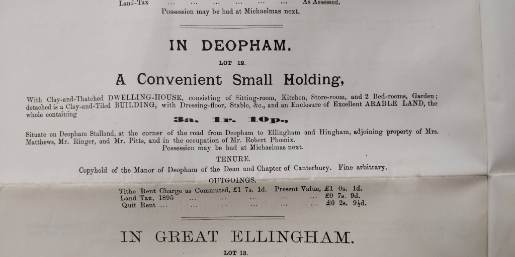
Reproduced courtesy of Wymondham Town Archive; their ref 423/2
The following extract from the 1906 OS map LXXXV.3 shows three pieces around and including the Red Brick House totalling 3.231 acres. This corresponds to the 3a 1r 10p of the auction particulars.
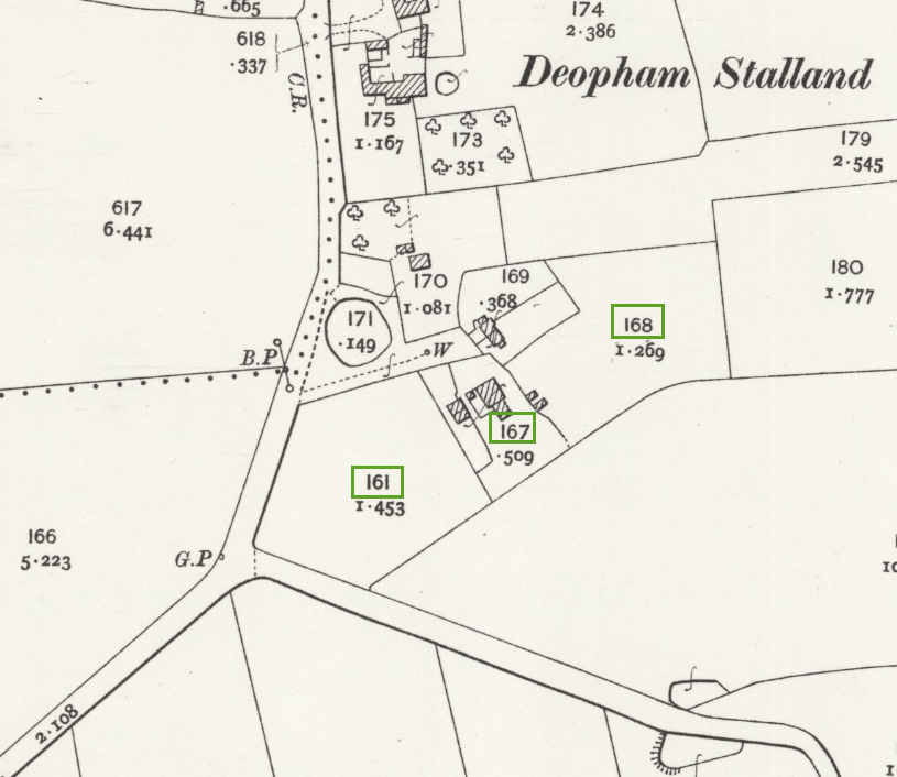
Map reproduced with the permission of the National Library of Scotland
1924 Arthur Long tenancy
On May 17th 1924, Arthur Long signed a Tenancy Agreement for this property; its owners were named as Alfred Pitts, Robert Pitts and Julian Pitts – all three described as residents of Chelmsford.
Arthur Long died in 1938 (details of his funeral are available here).
Phil Long’s understanding is that his son Norman Long vacated the house shortly after the death of his father and moved to Walnut Tree Farm, later returning back to Stalland Farm in 1949.
1940s
Mr. Brian Dye has advised (in an email to Phil Long) that his family lived in Stalland Farm (aka Red Brick House) until 1949.
The 1939 Survey indicated that Alred & Frances Dye with their son Graham were still living in Halffield Lane at the time of that survey, indicating that they moved to Stalland Farm some time after September 29th 1939 when the survey was undertaken.
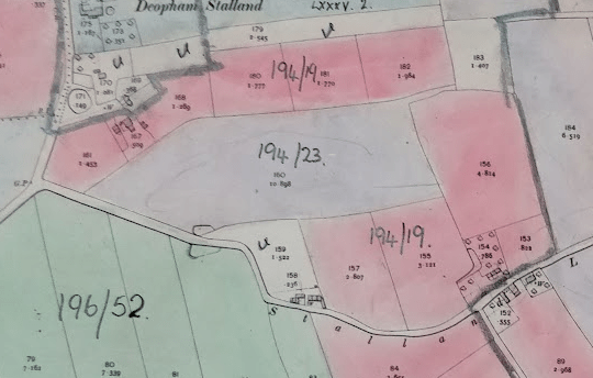
1941 Farm Survey
At the time of the 1941 Farm Survey, the Red Brick House had been subsumed into Walnut Tree Farm which was occupied by Mr. Norman Long. This survey does not mention Stalland Farm/Red Brick House. The owners of that farm were recorded as being:
Mr. W.M. Prewer,
Grange Farm,
Fritton,
Norwich.
and
Mr. E.A.R. Pitts
Colliston,
Upper Moulsham,
Chelmsford.
Details of the survey for that farm, including crops and ownership details, are available here where there is a map showing the full extent of the farm. The following is an extract from that MAFF map – the areas which are coloured in pink are parts of the Walnut Tree Farm lands. (The mauve, ref. 194/23, is part of Ivy Farm.)
1983 Photo
The following photo from circa 1983 appeared in the sales particulars for this house. The central upstairs window is “fake” being totally bricked up as part of the house design.

With thanks to Steve Mahoney for allowing sight of this photo.
| Date | Change |
|---|---|
| 30/11/25 | 1983 Photo |
| 12/7/25 | Revised 1940s paragraph |
| 24/2/25 | 1924 – 1949 details |
| 16/2/25 | 1815 Survey data |
| 12/2/25 | Published |
