Contents
- Other Names of Stalland Lane
- Manorial Court Records
- 1814
- 1946
- After World War II
- 1906 Map overlaid on 2025 Satellite Image
- 1962 – Stopping up redundant parts of Stalland Lane
- Navigation
Other Names of Stalland Lane
| Name | Source | Links |
|---|---|---|
Abutts the King’s Highway called Margate Lane This would appear to be a scribal error! In the 1699 Court of this Manor, the same premises are described as “abutts the King’s Highway called Margarett Lane, otherwise Stolland Lane, from Townegreene to The Stolland”. | 1643 Court of the Manor of Deopham of the Dean & Chapter of Canterbury | https://deophamhistory.co.uk/court-of-the-manor-of-deopham-of-the-dean-chapter-of-canterbury-september-1643/ |
| The King’s Highway called Margaret Lane, otherwise Stolland Lane from Towngreen to the Stolland in Deopham aforementioned | April 1689 Court of the Manor of Deopham of the Dean & Chapter of Canterbury | Court of the Manor of Deopham of the Dean & Chapter of Canterbury April 1689 |
| The King’s Highway called Margaret Lane, otherwise Stolland Lane from Town Green to the Stolland in Deopham | 1713 Court of the Manor of Deopham of the Dean & Chapter of Canterbury | https://deophamhistory.co.uk/court-of-the-manor-of-deopham-of-the-dean-chapter-of-canterbury-august-1713/ |
| The King’s Way called Margaret Lane, otherwise Stolland Lane, leading from Town Green to the Stolland in Deopham | 1805 Court of the Manor of Deopham of the Dean & Chapter of Canterbury | https://deophamhistory.co.uk/special-court-of-the-manor-of-deopham-1805/ |
| Stalland Road and No 8 | 1814 Inclosures – see map below | https://deophamhistory.co.uk/walnut-tree-farm-stalland-lane/#1814-description |
Manorial Court Records
Margaret Lane
The following text is an extract from the Latin record of the Court of the Dean & Chapter of Canterbury held on April 24th 1689 where Margaret Lane is given as an alternative name:

Translated: “the King’s Highway called Margaret Lane, otherwise Stolland Lane from Towngreen to the Stolland in Deopham aforementioned.”
1814
Stalland Road
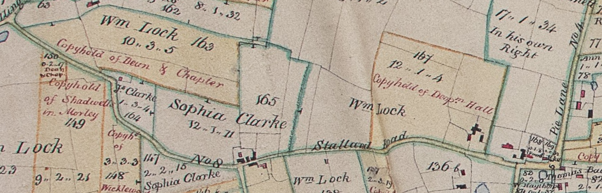
All rights reserved by Norfolk Record Office who hold the original; their ref is NRO C/Sca 2/86
1946
The following aerial photograph is dated July 9th 1946.


Reproduced with permission from Historic England; their reference is raf_106g_uk_1638_rp_3138.
After World War II
The following map supplied by Martin Jeffery, which was drawn up by his father Harold Jeffery, shows pre-war roads in red and post-war in green. This indicates clearly how Stalland Lane was straightened. It also shows the name “Potter” above the farm that was demolished when the runways were built.

1906 Map overlaid on 2025 Satellite Image

Reproduced with the permission of the National Library of Scotland
1962 – Stopping up redundant parts of Stalland Lane
The following announcement appeared in The London Gazette published on May 22nd 1962, and repeated on May 29th 1962; this relates to the closing of sections of the old road that had become redundant following the opening of the new straightened road.
NORFOLK COUNTY COUNCIL
Forehoe and Henstead Rural District
Notice is given that application will be made by the (Norfolk County Council to the Justices of the Peace sitting at The Court House, Wymondham, at 10 a.m. on Tuesday, 26th June 1962, for an Order under section 108 of the Highways Act, 1959, authorising the stopping up for the purposes of all traffic of three sections of the highway known as Stalland Lane in the Parish of Deopham over a distance of approximately 530 yards which are unnecessary following the realignment of that highway eastwards from its junction with the Little Ellingham-Deopham Stalland Road. The sections of highway to be closed are shown coloured blue on the plan deposited at County Offices, Thorpe Road, Norwich, and at the offices of the Wymondham Urban District Council, 14 Middleton Street, Wymondham. Any person using the highway or any person aggrieved by the making of the said Order has a right to be heard before the Justices.
Dated this 9th day of May 1962.
F. P. Boyce, Clerk of the Norfolk County Council.
County Offices,
Thorpe Road,
Norwich,
Norfolk,
NOR 47 A.
Navigation
| Date | Change |
|---|---|
| 9/12/25 | 1946 Aerial photo |
| 22/7/25 | Margate Lane |
| 1/7/25 | 1689 example |
| 10/6/25 | Further detail from Martin Jeffery |
| 14/4/25 | Published |
