Other Spellings:
Tungreen; Tun Green; Tunn Green; Tongreen; Tungrene;
Town Green; Towngreene; Townegrene.
Contents
- Origin of the Name
- Location
- References to Town Green (and its variants)
- Footnotes
- Navigation
Origin of the Name
tun / ton / town — Initially tūn meant simply fenced or enclosed. This evolved in Old English to refer to an enclosure with a dwelling; this sense continued to evolve as a collection of houses grew around the nucleus farmstead so that the meaning became “village” or “hamlet”.1
grene / green — a village green, grassy common, or open pasture.
A 17th-century “green” was usually a multifunctional working space rather than an ornamental landscape such as we would imagine nowadays. A traditional green would have been characterised by two features which were contemporary with its establishment:
1) a well, without which the community could not survive;
2) a church;2
3) a blacksmith (in this connection the application at the Manorial Court of June 16th 1718 for permission to build a forge on Town Green is relevant).
Clearly, Deopham’s Town Green is nowhere near the church. Citing as an example the village of Longham, it has been shown that “settlement-drift” could take place over the years, leaving a church located some distance away from the later village green.3
In addition to providing pasture for animals, the green would have served as a marketplace, a location for public meetings and a venue for celebrations.
Location
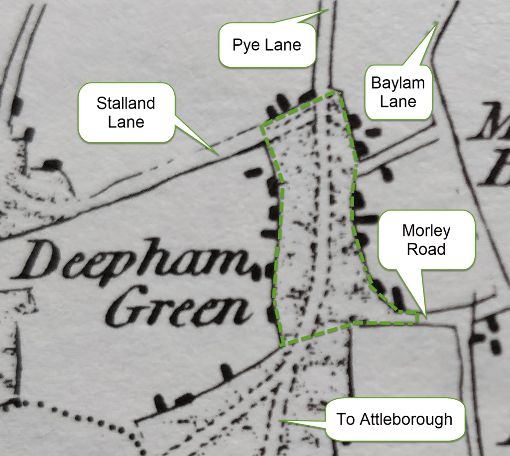
The following extract from Faden’s 1797 map of Norfolk gives an idea of the location and extent of Town Green as being the area within the dotted green line. This shows very clearly that the definition of a tūn or town being a collection of houses around a central green:-
References to Town Green (and its variants)
A Pasture called Town Green
The record of the Court of the Manor of Deopham of the Dean & Chapter of Canterbury held on September 23rd 1691 has a reference to a freehold property which abutts a “pasture of this Manor called Towngreen”. Another reference occurred in the record of the court for this Manor held on June 16th 1718 when permission was sought “to build a workshop or blacksmith’s forge in a pasture called Tunn Green”.
A Common called Tungrene
The Court Rolls of the Manor of Shadwells otherwise Cockerells recorded a property called Jex Close (also spelt Jecke’s Close and Jock’s Close) abutting “a common called Tungrene to the east”. An early example was the Court held on May 31st 1613, with regular repeat entries as the property changed hands until November 12th 1788. At this Court of 1788 Robert Curson was admitted and was still the tenant of this copyhold land and a further 6 roods in Haugh Field at the time of the 1814 Inclosures. The Inclosure Commissioners awarded him piece no 137:

Byway Passing Through
The description in the commentary on the 1814 Inclosure Map of the Attleborough Road (referred to by the Commissioners as Public Road No 4) stated that it ran from the north of Tun Green and then proceeded in a southerly direction “nearly in the middle of the said Green to South Hill Common”. This corresponds to what can be seen on the Faden map above. There is a full copy of the 1814 description of the Attleborough Road here.
Byways leading to and from Town Green
Town Green to the Stolland
This would be the road now known as Stalland Lane. The full description found in the Court Rolls was “The King’s Highway called Margaret Lane, otherwise Stolland Lane, from Town Green to the Stolland”. This reference occurs in transactions relating to a parcel of land occupying 2 acres and 2 roods which was copyhold of the Manor of Deopham of the Dean & Chapter of Canterbury. An early mention of this plot and its adjoining way can be found in the Court of September 22nd 1699. The last mention was in the record of the special Court held on April 22nd 1805.
Town Green to Deopham Church
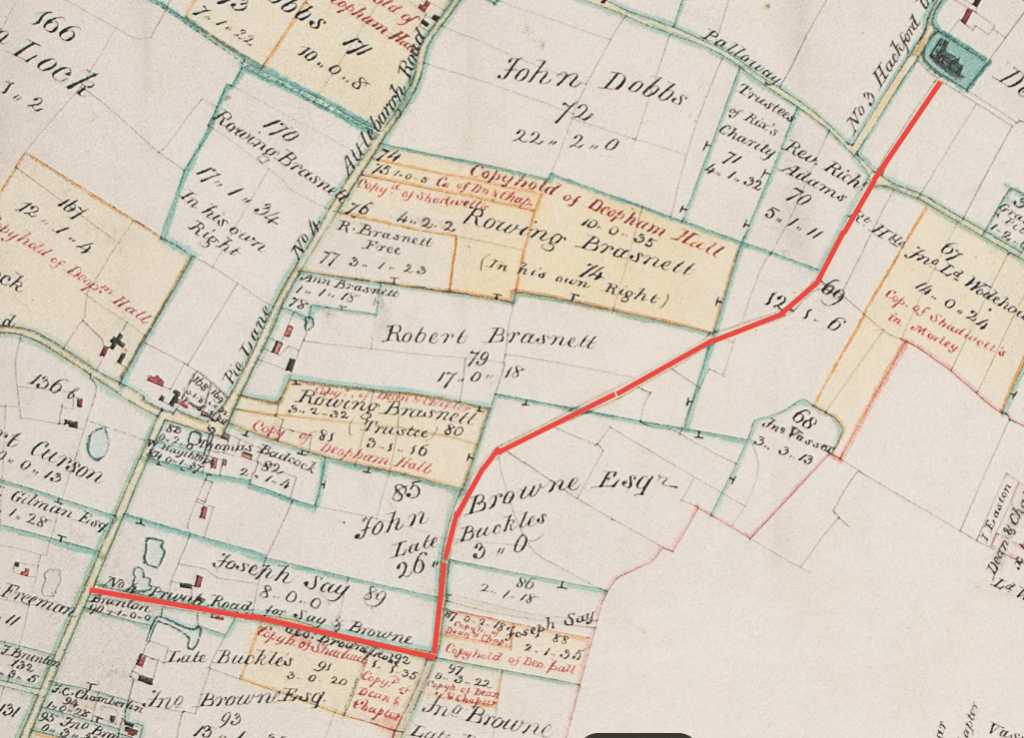
Whilst this may have taken travellers up Pye Lane and along Vicarage Road, the more likely route would be along Baylam Lane which prior to the 1814 Inclosures ran from a point approximately half way between Stalland Lane and the Morley Road directly up to the church’s south porch. The northern end of Baylam Lane was stopped off during the inclosures process.
All rights reserved by Norfolk Record Office who hold the original; their ref is NRO C/Sca 2/86
Another reference to there being route from the church to Tungreene occurred in the record of the Court of the Manor of Deopham of the Dean & Chapter of Canterbury held on September 2nd 1647 when John Cooper was amerced 3d for “an encroachment onto Church Way from Deopham Church to Tungreene”.
Town Green to Morley Green
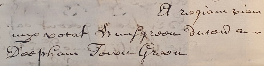
This would be the road now known as the Morley Road. The full description found in the Court Rolls was “the King’s Highway called Hunsgreen running from Deopham Town Green to Morley Green”. The following sample extract is taken from the record of the Court of the Manor of Deopham of the Dean & Chapter of Canterbury, March 28th 1729:
A Footway to Southill
In the Court Roll for the meeting of the Manor of Deopham of the Dean & Chapter of Canterbury held on September 23rd 1685 there is a reference in a curious mixture of Latin and English to Edward Burman esquire being fined 10s. The misdemeanor was that he “Hath stopped up” a certain way called “a footway” from Town green in Deopham to South hill in Deopham. A year later, he was fined again for the same offence.
Property on Town Green
A Tenement called Cookes
There are references in the Court Rolls of the Manor of Deopham Hall to a copyhold tenement called Cooke’s. At the Court held on November 9th 1704 it was recorded that Gilbert Poynton, a farmer in Morley St. Buttolph, took over “a copyhold tenement called Cookes situated in a place called Tungreen Street4 in Deepham”. This came with 1½ acres of copyhold pasture adjoining the messuage.
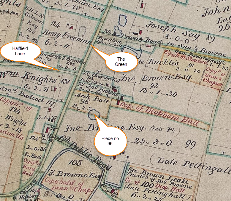
There is a final reference to the property under this name in the Court of 1814 following the Inclosure awards. The house and land were consolidated by the Commissioners into 3½ acres & 2 perches which were identified as piece no 96 on their Inclosures map. Whilst there is no guarantee that the post inclosure location was the same as that before, in this case it would be consistent:
All rights reserved by Norfolk Record Office who hold the original; their ref is NRO C/Sca 2/86
A Messuage with 1½ acres
The Court Roll for the Court of the Manor of Deopham of the Dean & Chapter of Canterbury held on September 14th 1643 recorded that John Chamberlyn was a freehold tenant of “1½ acres with a Messuage built in Tongreen in Deopham” for which he was required to pay an annual rent of four pence to the Court.
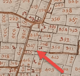
The 1815 survey of Deopham recorded that an arable plot of 1 acre, 3 roods & 34 perches was “Part of Town Green”. This was identified as piece no 347 on the 1815 map.
Since this piece lies just to the north of Baylam Lane, the farm to which it belongs can be identified as that now known as Willow Farm.
Property adjoining Town Green
During the Commonwealth period (1649-1653), the manors were disbanded. There is a document in the Canterbury Archive (see here for a full transcript) recording the sale of the Manor of Deopham of the Dean & Chapter of Canterbury. One of the properties sold was described as:
… all that Little Cottage and Close of arrable Land thereunto adjoyneing with their and everie of their appurtenances commonly called Hawfeild abutting to the Lands late of Francis Bubbin on the west and to a certain Common called Tungreene Common on the East, Containing by estimation Foure acres more or lesse.
The records of the Manor of Deopham Hall refer to properties abutting Town Green:-
The record of the Court of November 30th 1716 mentioned a plot of 2 roods (= ½ acre) which abutted Tunn Green to the East. The last mention of this plot appears to be in the Court Roll for their Court held on September 7th 1775.
A second piece of land was described in the Deopham Hall Court Rolls as 3 acres, with Hawfield lane to the South and Town Green to the East. This first appeared at the Court held on April 21st 1724 and continued to appear until the Court held on December 10th 1807.
Footnotes
- A.H. Smith, English place name elements, Vol II, Pp 188ff ↩︎
- W.G. Hoskins, The Making of the English Landscape, 2006 edition , pg 40 ↩︎
- Christopher Taylor, Village and farmstead : a history of rural settlement in England, pg 128, and
Peter Wade-Martins, East Anglian Archaeology Report No. 10, pp 33ff. ↩︎ - Street: A.H. Smith, op. cit. pp 161f, gives the meanings “a Roman road, a paved road, an urban road, a street”, however he also states that the word later came to designate “a straggling village”. ↩︎
Navigation
| Date | Change |
|---|---|
| 25/5/26 | Published |

